Appreciating Clouds
Bruce Couch Website
fact
Badger
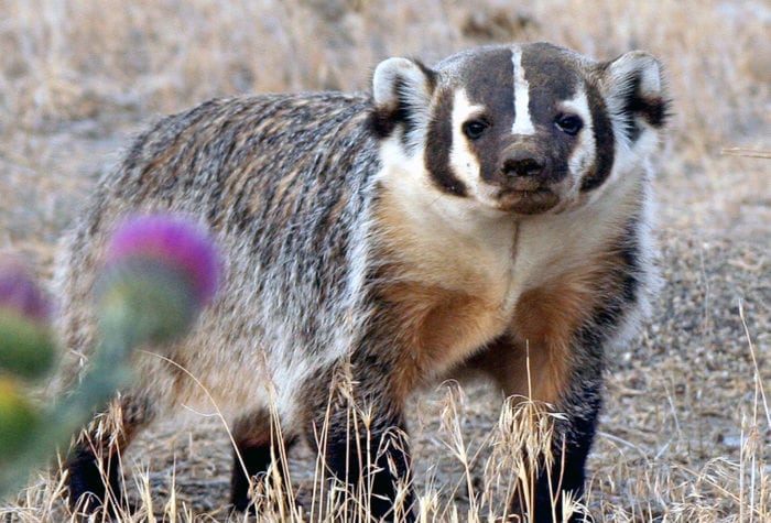
Badger
Badgers are generally nocturnal, but, in remote areas with no human encroachment, they are routinely observed foraging during the day. They prefer open areas with grasslands, which can include parklands, farms, and treeless areas with crumbly soil and a supply of rodent prey.
Badgers are born blind, furred, and helpless. Their eyes open at four to six weeks.
Latin name: Taxidea taxus
voices
Helen Harbin, ONDA Board Member
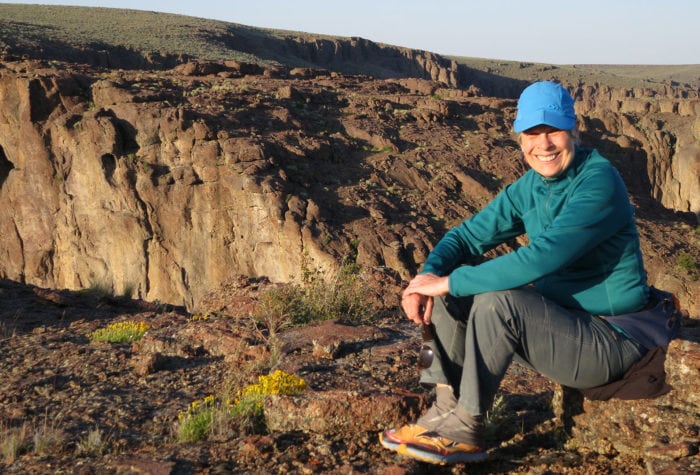
Helen Harbin, ONDA Board Member
“I connect with Oregon’s high desert through my feet, my eyes, my sense of smell, and all the things I hear. Getting out there is a whole body experience.” Supporting ONDA, Helen says, not only connects her with wild landscapes, but is also a good investment. “I felt like if I gave them $20, they might squeeze $23 out of it.”
fact
What defines Oregon’s high desert?

What defines Oregon’s high desert?
Bounded by the Cascade Mountains to the west and the Blue Mountains to the north, Oregon’s high desert covers approximately 24,000 square miles. Annual rainfall in the high desert varies from 5 to 14 inches. The average elevation is 4,000 feet; at 9,733 feet, the summit of Steens Mountain is the highest point in Oregon’s high desert. The terrain of the high desert was mostly formed by a series of lava flows that occurred between 30 and 10 million years ago.
Sources: The Oregon Encyclopedia; Wikipedia
Location: Beaty’s Butte looking west | Photographer: Greg Burke
Picture-perfect clouds! These are cumulus humilis clouds—the “humble” cumulus cloud, one that is wider than it is deep. Each of these clouds is the sign of a successful thermal—a parcel of moist, rising warm air that has risen from the sun-warmed earth. As each thermal rises, it cools and, at a certain altitude (known as the condensation level), the mass of invisible water vapor molecules in the thermal condense into liquid water and become visible as a cloud. The flattened, grayish bottoms of cumulus humilis mark the condensation level where this magical transformation happens. These particular cumulus clouds are known as “fair-weather cumulus” and indicate stable air that will suppress further growth. If fair weather should turn foul, these humble clouds will broadcast this news to cloud watchers: the clouds will develop through a predictable sequence into larger cumulus mediocris (clouds as tall as they are wide) then cumulus congestus (clouds taller than they are wide) and then cumulonimbus.
Location: Hart Mountain, looking north into the Warner Valley | Photographer: Jim Davis
Fog is a clunky name for a cloud—especially one so delicate and ethereal as these. Fog is a type of stratus cloud that forms at ground level. Like all clouds, fog forms when warm, moist air cools. Often that cooling is done when the moist air comes in contact with the ground (and/or water), which is why lakes, ponds, rivers and their valleys are common places for fog to form. We might say the fog in this beautiful photograph is “lifting” or “burning off,” but it is doing neither. Fog evaporates from beneath as the sun shines through the clouds and warms the earth and water beneath the fog. That warming causes the liquid water that we see to evaporate—or change to vapor, which we cannot see. When the fog no longer reaches the ground, it is referred to as stratus. Here, you could even call it stratus fractus—fractus meaning “broken.”
Location: Oregon Badlands Wilderness, looking north | Photographer: Greg Burke
Imagine a sunset or sunrise without the clouds! One of the most important things for cloudwatchers to remember is that pure sunlight is white but is composed of “all the colors of the rainbow.” The water molecules and ice crystals in clouds do a truly spectacular job at scattering that sunlight so that we see its component colors red, orange, yellow, green, blue, indigo, violet—colors you learn in grade school by the acronym ROY G. BIV).
When the sun angle is low in the sky, the sun’s longest wavelengths are most successful at passing through the lower portion of our atmosphere and an abundance of small particles—dust, haze, pollen, smoke, pollutants, for instance. When these “warrior wavelengths” as I like to call them reach the clouds—high cirrus clouds in this photo—those longer red, orange, and yellow wavelengths are reflected to our eyes and we have sky bling in the Badlands.
Location: Alvord Dry Lake, looking east | Photographer: Alan Majchrowicz
Clouds are static in photographs (of course) and may seem static when we glance at them quickly in nature, but clouds are dynamic phenomena—developing, maturing, and dissipating more quickly than we ever imagine. The lifespan of a cloud is usually less than an hour. This cumulonimbus cloud is nearing the end of its life. How can we tell? Cumulonimbus clouds develop in predictable stages—from the small, cumulus clouds (the iconic lobe-shaped cloud) to the much larger, more mature “cauliflower” shaped billowing ones. You can see evidence of the “cauliflower” in the upper right portion of this photo. When the cumulus congestus reaches a certain high altitude, the water droplets in the cloud freeze and begin to spread out and give the cloud top an anvil shape (visible here in the center-left of the cloud top). Though this clouds base may be below 6,500 feet, its icy top could be near 45,000 feet. Were you to be watching this cumulonimbus in real time, you would see it disappear before your eyes as it snows and rains itself out from its base. Much of this precipitation will evaporate before reaching the ground–a cloud feature known as “virga.”
Location: Mount Jefferson as seen from Pilot Butte | Photographer: Bruce Couch
There are times when cloudwatchers should simply be awestruck and just gawk. This is one of those times. The clouds here have outdone themselves. Starting at the lowest clouds and moving up, there is a skirt of low, clumpy cumulus humilis (the heaps of humble clouds) gathered around the snow-clad Mt. Jefferson and a banner cloud drifts off its peak. Downwind of the peak and higher above it, altocumulus lenticularis (nicknamed “lennies”) hover in a stack formation and also as individual silvery lenses (lenticularis means “lens-shaped” in Latin). Lennies often form downwind of peaks of mountain ranges such as the Cascades and Sierras. The clumpy, ragged cloud beneath the stacked lennie is a puzzle to me. My go-to meteorologist (who lives in the Arizona desert) took a look at this photo and suggested it might be a “rotor cumulus fractus,” a small cumulus cloud with a flat top and a ragged evaporating bottom (a new cloud for me!). Behind this formation in the photo are the smooth gray altostratus (mid-level layer cloud) and, above that, brighter cirrostratus (high layer cloud). A truly awesome high-desert skyscape!
And what about the clouds in the photo up top, you ask?
Location: Alvord Desert Playa | Photographer: Bruce Couch
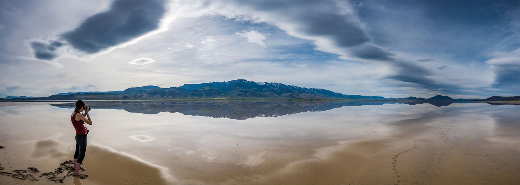 Altocumulus clouds are a mid-level cloud (6,500-23,000 feet above the ground) and are one of the most varied of the ten official cloud types. This one—beautifully warped by the panoramic view—is an altocumulus lenticularis, a smooth, “lens-shaped” cloud, nicknamed “lennies.” On the right of the photo you can see a small pile of lennies, which is how these surreal clouds often appear over peaks and mountain ranges, such as the Cascades. They are, as you can easily imagine, the clouds that started the U.F.O. craze. Above the gray-shaded lennies is a higher layer of cirrostratus—a smudgy kind of cloud composed of ice crystals. No matter how strange or strangely warped the clouds you observe are, capturing their reflections in still water creates a doubly compelling photograph and may inspire your own reflection: How could these two forms of water—basic H20—look and act so very differently?

Take Your Cloud-Gazing Up Five Notches
Join author Maria Mudd Ruth as she takes you on a tour of clouds in Oregon’s high desert and the wide-open, wild landscapes that make for spectacular cloud viewing. Learn what makes the clouds so dynamic, so varied, and so universally appealing. How do clouds take shape? Is there an easy way to learn their confusing Latin names? How can you enjoy the clouds in a new light on your next high desert adventure?
Get Tickets
About the author
Maria Mudd Ruth is the author of more than a dozen natural history books for the young readers, general audiences and "accidental" naturalists, including "Rare Bird: Pursuing the Mystery of the Marbled Murrelet." Her latest book, "A Sideways Look at Clouds" (Mountaineers Books, September 2017) is a work of narrative nonfiction that blends science, wonder and humor to take lay readers on the scenic route through the clouds.
Visit Author's WebsiteAppreciating Stormy Skies
Maria Mudd Ruth, author of “A Sideways Look at Clouds,” is fascinated by clouds. In this post, she identifies the clouds seen in the stormy skies over Oregon’s high desert. […]
Read MoreHigh Desert Speaker Series
Each year Oregon Natural Desert Association hosts a speaker series featuring intriguing stories, exquisite photography, and fascinating natural history from the high desert and across the West. The 2026 Speaker […]
Read More