When I tell people I am doing Greater sage-grouse monitoring for my internship with ONDA, their eyes widen with excitement as they ask me if I’m going to see any sage-grouse or have seen any sage-grouse. But this work revolves more around spying the habitat – observing the small green shoots, the flowers, the sagebrush large and small, and sometimes the invasive weeds. While I would love to see this magnificent bird in the flesh, especially during its mating season in its gathering place called a lek, I’m just as thrilled to be working in the high desert among the sagebrush, wildflowers, and scurrying critters as I would be with sage-grouse.
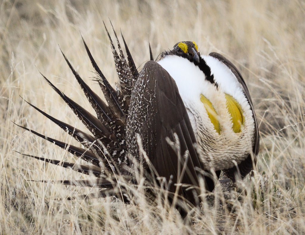
Greater sage-grouse. Photo by Barb Rumer.
Every week Erin Kilcullen and I, both summer interns for ONDA, drive four hours southeast to the Beatys Butte area in Oregon, a place most people have never heard of and few people have ever been. For the first couple of weeks the drive seemed extraordinarily long; now that we’re familiar with the bumps, bends and straight stretches of road, four hours flies by. Each week is a different set of subplots, a different camp site, and different weather. Nothing is the same, and yet there is a certain rhythm and repetition to the surveying that has become a comforting routine. We drive out on the sometimes precarious roads as close to our selected subplot as we can before switching on our GPS and heading out on foot. Some subplots are as close as 500 feet from the road, some as far as 2.6 miles. Erin and I often marvel at how helpful and incredible a GPS unit is, especially in areas where you can easily mistake one direction for another. That marvel is forgotten once we’re within 15 feet of the exact geographic location and we’re cursing the GPS for being persnickety, causing us to walk in small circles for five minutes before we can find ourselves standing directly on the point.
Once we’re at “0 feet from target,” we stake in one end of a 50-meter tape and walk it out in three directions we call transects at 0, 120, and 240 degrees. After taking a picture at each end of the transect, using a handy smartphone app called Solocator that embeds the latitude and longitude into the picture, we walk along the tape and drop a thin metal pin at each meter. Here we use our smartphones again to record on a form what vegetation is touching the pin if any (generalized into categories such as sagebrush, shrub, perennial grass, annual grass, native forb, invasive forb, etc.), the height of the vegetation (using a small piece of PVC pipe that’s been transformed into a measuring stick), and the base layer (soil, duff, moss, rock, etc.). After we’ve entered in all the information for a given point, the form is saved in a queue on the phone that gets uploaded to a server once we’re back at the office. We continue dropping the pin and recording data at every meter through 50, then wind the tape back up and go through the process again for the next two transects before moving on to the next subplot.
In the four weeks Erin and I have been monitoring, we’ve experienced the full range of desert weather. The first week, midway through May, our time was cut short by a late winter storm. We both were layered up in our best winter gear to deal with the cold, damp conditions, in the middle of our last transect for our first subplot of the day when the air chilled noticeably, followed moments later by a loud rumble of thunder and strike of lightning that left us stunned like deer in headlights. Looking over where the dark clouds loomed, we saw a wall of white moving quickly toward us. Wasting no time, we packed up our equipment and ran as fast we could over the sagebrush to our car, quickly stopping back at our camp to throw the tent with our sleeping bags still in it in the back of the car. Three weeks later we were wearing tank tops and applying sunscreen at our first subplot of the day, the heat of the desert already intense at 8 a.m., gulping water between each transect.
Though we were exhausted that evening, feeling wilted by the sun and physically drained from hiking the most we had yet, we were rewarded by what may be the best sunset I have ever seen. No powerlines obstructed the view, no noise pollution from cars or planes hummed in the distance, and no text messages or apps distracted us. It was just us and the desert, serenaded by the crickets and birds. In the dusk, the green of the sagebrush deepened, causing the yellow wildflowers to glow in the fleeting light. Cumulus clouds covered the sky overhead except for a sliver along the horizon where the rays of the sun dissolved from gold to amber to the most brilliant pink I have ever seen. It was a sight so picturesque and spectacular that I didn’t look away until it faded into the blue of the night, and I was reminded again of why I love the desert and why I wanted to be an intern with ONDA — so I could experience and help protect the beauty and health of Oregon’s deserts.— Anne White