Get into the Fremont

Corinne Handelman

We hear a common refrain from people when they get back from a trip in the Fremont:  “I wish I’d gone hiking in the Fremont years ago! If only I’d known about it!”

If you’re not familiar with the wonders of the Fremont, please allow us to introduce you! Here are our best tips to visit the Fremont-Winema National Forest.

About the forest

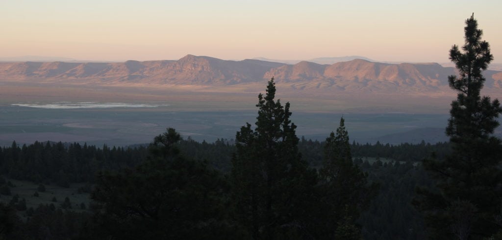
The Fremont-Winema National Forest covers about 2.3 million acres across southeastern Oregon. This large swath of land managed as a single forest came about when the Fremont and Winema National Forests were combined in 2002. The original Fremont National Forest was named after explorer John Fremont when it was established in 1908. This Fremont section encapsulates many of the rock outcrops and wide expanses now home to the Oregon Desert Trail and Fremont National Recreation Trail, including Winter and Abert Rims. The Winema National Forest was named after a heroine of the Modoc War of 1872, and much of the land was purchased from the Klamath Tribe. Since this is such a large combined National Forest, we’ll focus on the section along ONDA’s Oregon Desert Trail within the Paisley Ranger District of the Fremont.

voices

John Cunningham, ONDA member and volunteer

John Cunningham, ONDA member and volunteer

Restoration is hard slow work. It takes hold, or it doesn’t, in fits and starts. The immensity of the need can be discouraging, but we must carry on. I am so thankful ONDA carries on.

watch

Sage Steppes

Sage Steppes

voices

Ryan “Dirtmonger” Sylva, ODT thru-hiker 2017

Ryan “Dirtmonger” Sylva, ODT thru-hiker 2017

“To me, it’s a thru-hike in an isolated place that promotes a conversation in land management, ethics and usage. Hiking across a vast and remote landscape and having a random and chance encounter with cowboys and hunters to discuss how ‘all of us’ should treat the land, how we all have a responsibility, no matter our political leanings, really showed me the pulse of the people in rural areas, especially here out west.”


What to expect

This area holds high elevation pine forests that open to expansive views of the Basin and Range to the east.

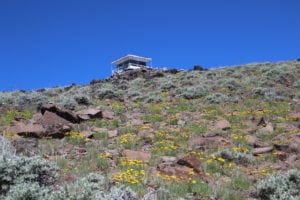
Depending on your exact location, you’ll have vantages all the way to Steens Mountain and south to Mount Shasta. Fire lookouts dot high buttes along the 157-mile Fremont National Recreation Trail. Some lookouts are staffed by U.S. Forest Service employees; others are available to rent as cabins if you want a slightly more luxurious experience than sleeping in town or on the ground.

Due to the high elevation, this area will be snow-covered during a typical winter and dry during the summer. There is more water along the Fremont National Recreation Trail than other sections of the Oregon Desert Trail, and you can use the ODT maps and databook to find the best information on water availability. Most roads into the Fremont are in better condition than those further out into Oregon’s high desert but will be gravel and wash-boarded, so always drive with caution and check current conditions before heading out.

In the springtime through early summer, you can expect to find wildflowers dotting the Oregon Desert Trail, including native Oregon sunshine, paintbrush and bitterroot, in between sagebrush and bunch grasses. Abundant wildlife populations can also be found here, including pronghorn antelope, mule deer and migrating birds in the spring and fall.


Where to go

**As of January 2022, the Fremont National Recreation Trail between Moss Pass and Cox Pass is closed due to the Cougar Peak Fire, including the road to Moss Pass. Always check with local land managers before you head out.** 

The Fremont National Recreation Trail overlaps with the Oregon Desert Trail for 62 miles with a variety of access points along that stretch.

Short day hikes are possible from a variety of car-accessible trailheads along the Fremont National Recreation Trail. For a weekend backpacking trip, you can shuttle cars from any of these access points, or create an out-and-back trip from a single trailhead.

From Chewaucan Crossing, known for its free campsites along the river and fly fishing, you can hike south along the Oregon Desert Trail for any distance as a choose-your-own-adventure out and back trip.

Avery Pass and Morgan Butte are also accessible to most vehicles, where you can walk in either direction and enjoy some time on the Fremont National Recreation Trail and ODT. The Morgan Butte lookout is one of a few remaining staffed fire lookout towers, and it offers amenities for visitors. You can drive up and enjoy the view, then hike north or south on the ODT. ONDA stewardship volunteers recently cleared about four miles of trail from the south side of Morgan Butte, up over the ridge and north toward Avery Pass.

At Moss Pass, you’ll find a nearby horse camp, a spring and plenty of space to camp out. From here, you can hike north or south on the Oregon Desert Trail.

Searching for an even longer adventure? You can also hike, bike, or ride horseback the entire 62 miles of the Oregon Desert Trail from Paisley to Vee Lake in the Warner Mountains. Look for Oregon Desert Trail resources on sections seven and eight.


Further information

**As of 2023, there is no longer a gas station in Paisley. The nearest gas stations are 75 miles apart in Summer Lake and Lakeview. Do your research and check with locals for the most up to date information.** 

Find nearby amenities in our Oregon Desert Trail town guide. Paisley has a mercantile, saloon and more.

Looking to stay in the area longer or relax after a long few days on the trail? You can stay and soak at nearby Summer Lake Hot Springs or newly reopened Hunters Hot Springs in Lakeview.

Paisley’s local U.S. Forest Service Office is a wealth of information on recreation and current conditions

Find all Oregon Desert Trail maps and more on our trail resources page.

Scroll through the photos below for scenes from ONDA’s July 2018 stewardship trip in the Fremont-Winema National Forest, and check out our Flickr album for even more.

View from Morgan Butte

Corinne Handelman

Stewardship volunteers on the ODT

Corinne Handelman

Gravel roads lead to trailheads

Corinne Handelman

Hikers, horses and mountain bikes are welcome

Corinne Handelman

ONDA stewardship volunteers

Corinne Handelman