-
Distance
2.6 - 12 miles round-trip (many off-trail hike options)
-
Best Times To Visit
Spring
-
Dificulty
5
-
Closest Town
Antelope, Oregon
-
Drive Time
2 hours from Bend, Oregon
Description
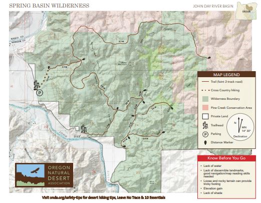
Spring Basin Wilderness is a scenic remote escape that is ideal for those who love off-trail backcountry exploration. In this wilderness area, designated in spring of 2009, the recreation infrastructure consists of old two-track roads that extend along the west, north and south sides of the area. These roads (marked trails on the maps) are faint and can be hard to find as you hike in the area, so good navigation and terrain reading skills are suggested. Horse Mountain stands in the center of the wilderness, acting as a beacon and very clear landmark to note as you hike in the area.
The route into Spring Basin Wilderness leaves the BLM kiosk and heads cross-country north for .4 miles until reaching a trail that continues up an unnamed canyon. The path climbs 800 feet past interesting rock formations, until arriving at a cairn at the top of the climb. Trails branch out to the left and right on old two-track roads that have all but disappeared among the grasses and wildflowers. Continue on the trail of your choice, and if you plan on hiking past the wilderness boundary into Pine Creek Conservation Area, please fill out a self-issued permit by a kiosk just east of the Clarno Road entrance.
Driving Directions
From Bend, follow Highway 97 north to Madras. Continue on highway 97 for 17 miles, then turn right on Highway 293/Antelope Highway. After 13.5 miles, continue onto State Highway 218 E. Turn right onto Clarno Road. Proceed 3.5 miles on dirt road.
Parking can be found at a BLM trailhead on Clarno Road, about 3.5 miles from the junction with Highway 218 (due to a small parcel of private land at the base of the entrance canyon, please continue to the BLM trailhead to park). Another option for entering the wilderness is to continue on Clarno Road another 1.5 miles past the trailhead to a spur trail marked by a brown post, which leads up Spring Basin Canyon. A locked gate and adjacent private land prevents driving all the way to this trail, and there is NO short or long term parking near the private gate, so to reach this access point one must park at the BLM trailhead and walk the road to the trail. While signage on this gate indicates otherwise, there is no requirement for written or verbal permission from any landowner to go through the gate, and walk or ride a horse on the County road accessing Spring Basin Wilderness. Ensure you stay on the road until reaching BLM land.
Additionally, the public may access Spring Basin Wilderness via the Confederated Tribes of Warm Springs’ Pine Creek Conservation Area trails from Highway 218. A free permit is required to hike in Pine Creek Conservation Area and can be obtained online or at one of the trailhead kiosks on Highway 218.