How To: Raft the Lower Owyhee

Author: Corinne Handelman  |  Published: May 14, 2019  |  Category: How-To  |  Updated: December 28, 2021

Tips to plan your desert rafting trip

Rafting the lower Owyhee River is a once-in-a-lifetime experience that introduces you to some of the most spectacular and untouched high desert landscapes found in eastern Oregon. Deep canyon walls, riverside camps, and hikes climbing to sweeping vistas are all highlights of this trip. Just be sure to gather some information ahead of time and check river levels before you head out!

fact

Far from Big Macs

Far from Big Macs

There is a point in the Owyhee region, in northwestern Nevada, that is, at 115 miles away, as far away as you can get from a McDonalds in the U.S.

Source: http://www.datapointed.net/2010/09/distance-to-nearest-mcdonalds-sept-2010

watch

Julie Weikel on Wilderness

Julie Weikel on Wilderness

watch

Chad Brown on Fly Fishing

Chad Brown on Fly Fishing

Corinne Handelman

Corinne Handelman

Corinne Handelman

Corinne Handelman

Plan ahead

The Owyhee basin is predominantly fed by snowpack, which can mean an inconsistent river season each year. Typically, paddlers want to visit the Owyhee when the river is flowing at 1,000 – 6,000 CFS (cubic feet per second), which frequently means trips in mid-March through May.

Understanding the different classes of river rapids is also critical to planning a trip. The lower Owyhee River from Rome to Birch Creek is mostly flat but features about a dozen named class III rapids and two class IV rapids, depending on river levels. Whistling Bird and Montgomery are the class IV rapids, both of which can be easily scouted but only Whistling Bird is easily portaged. If you are a more experienced boater, you can consider paddling the middle Owyhee River from Three Forks to Rome for more class IV rapids and the typically portaged Class V+ Widowmaker Rapid.

Car shuttles are another consideration to plan for since the road to Birch Creek is extremely challenging and requires a high clearance vehicle with sturdy tires due to a steep, narrow road and multiple stream crossings. The standard take-out for the lower Owyhee is at Birch Creek to avoid paddling flatwater on the Owyhee Reservoir to get to Leslie Gulch. You can also hire a shuttle service to pick you up at Birch Creek and bring you back to your cars left at the Rome launch site.

To follow permit regulations, you’ll need to bring a camp toilet, frequently called a groover. This camp toilet is one of many requirements for a river trip, including a fire pan if you wish to sit around an evening campfire. Be sure to follow Leave No Trace principles and check for fire restrictions before heading out.

Once you’re there

During years with strong river levels like 2019, the Owyhee is more crowded than usual. To respect other groups, pick your campsite with consideration for your group size. The largest groups are 20 people, so if you only have a few friends with you, choose a smaller campsite and leave larger areas open for big groups.

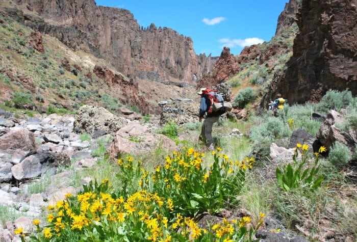
Hikes are accessible from different campsites along the way and can be a highlight of the trip, but you won’t find trails easily marked. Look for footpaths from Hike-out, Pruitt’s Castle, Lambert Dome, and Pothole camps as a start. Don’t skip the hot springs, where some paths along the river might lead you!

Look out for Native American cultural sites along the way, including petroglyphs carved into boulders, and be sure to take only photos and leave all artifacts where you found them.
Corinne Handelman

Corinne Handelman

Corinne Handelman

Corinne Handelman

Make your list. Check it twice!

Ask anyone who’s floated the Owyhee and there are a few items you won’t want to forget on your packing list. Our top recommendations include binoculars and plant, geology and bird identification books as you take time to slow down and observe your high desert surroundings. A waterproof river map will help you anticipate upcoming rapids and identify campsites along the way.

Finally, it’s always wise to bring lots of layers since springtime in the Owyhee has a reputation for highly variable weather. During warm days you’ll want sunscreen, a wide-brimmed hat and sun gloves. Other weeks there can be hail and thunderstorms, so synthetic insulation is key. A shade tarp or easy-up tent will help keep away sun or rainy weather once you’re in camp.

Further Information

Does this sound like too much work to prepare or do you not have the skills to self-support a rugged trip like this? Go with a guide company! There are many to choose from, including Northwest Rafting Company, Ouzel Outfitters, Momentum River Expeditions, and others.

A great resource to start your planning is the BLM guide to the entire Owyhee River, which has information on permit requirements, rapids, and campsites. Checking the USGS river gauge at Rome will be necessary, and the statewide snowpack map can be helpful since higher snowpack means more water to melt and feed river flows.

If you are looking for a tangible guide that comprehensively covers every tributary and the main Owyhee River, then grab a copy of Bonnie Olin’s The Owyhee River Journals.

Before or after your trip, take a few minutes to share your thoughts with Oregon Senators Ron Wyden and Jeff Merkley on why the Owyhee Canyonlands is such a special place and worth permanent conservation protections.