Journey

A personal adventure to Wilderness Study Areas in the desert: part I

Mark Darnell

ONDA’s Wild Desert Calendar spurred Mark Darnell to visit Wilderness Study Areas (WSAs) throughout Oregon on the hunt for his own high desert images. Mark takes us through his adventures visiting lesser-know WSAs and shares how that journey became so much bigger than what he had expected.
Story and images by Mark Darnell

The hunting knife in my left hand, poised for use, the trekking pole in my right, poking ahead through the brush, my head swiveled as I solo hiked off trail up a narrow canyon with rim rocks looming 30 feet directly overhead. I whistled and sang to cope with the fear. This was the perfect place for a cougar attack. Surely the rare cougar attack that killed one person and injured another yesterday in Washington State was just a fluke. But I couldn’t seem to believe any rational arguments at the moment. What was so damn important that I was putting myself in this situation so far from any help? A simple photograph?

• • •
fact

Swallowtail

Swallowtail

The Oregon Swallowtail butterfly is the official state insect of Oregon and a true native of the Pacific Northwest. The Swallowtail can be seen in the lower sagebrush canyons of the Columbia River and its tributaries, including the Snake River drainage area.  Source: State Symbols USA

Latin name: Papilio oregonius

fact

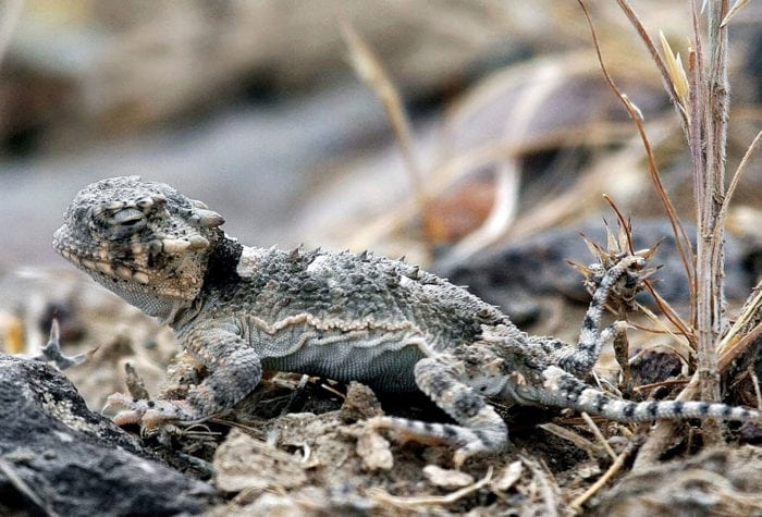
Young Desert Horned Lizard

Young Desert Horned Lizard

In the summer these lizards begin foraging for food as soon as their body temperature rises as the heat of the day increases. They feed on slow-moving, ground-dwelling insects. In the fall they hibernate by burying themselves in the sand.

Latin name: Phrysonoma platyrhinos

listen

South Fork Crooked River and Birds

South Fork Crooked River and Birds

My original plan was to spend two months in the spring visiting lesser-known Wilderness Study Areas (WSAs) and to bring back pictures for possible publication in ONDA’s upcoming Wild Desert Calendar. WSAs have been identified by the BLM as having wilderness characteristics but do not currently have permanent legal protection. ONDA is working to obtain the permanent protections these wild places deserve. Although my aim was to photograph these areas, my mission turned in to something unexpected, much larger and much more important.

I began my self-assigned solo mission with the South Fork Crooked River WSA, and, losing the first day to the first flat tire on my pickup in thousands of backroad miles, I returned the second day to start the journey. With six inches of fresh snow underfoot, I followed a Jeep road off GI Road up to a ridge, studying every animal track in the snow that crossed my route. Lots of deer and elk. On the adjoining plateau, I struck off cross country to the edge of the South Fork Crooked River canyon.

Sun glinted off the snow as I surveyed the confluence of Pickett Canyon and the rushing green rapids of the South Fork. During the return, the loud sounds of rocks tumbling over a muffled snow blanket alerted all my senses as I headed back down the ridge. Fully expecting a large herd of deer, I quietly approached around a blind corner and suddenly confronted a herd of wild horses 50 feet away. The stallion’s defiant stare stopped me dead as the herd quickly trotted into the woods. An exhilarating start to the mission.

South Fork Crooked River WSA

Solo exploring is usually necessary for an outdoor photographer to find the best compositions and wait for the best lighting conditions. Cross-country travel alone, although it requires careful planning and execution, is an opportunity to heighten your senses. In a remote landscape, freed from conversation with a partner, your mind is fully engaged in watching every uneven step, every plant, every animal sign and every cloud.

An entire week was needed to explore some of the many WSAs near Mitchell, Oregon.  In the Painted Hills Proposed Wilderness Area (PWA) south of the national monument area, seldom visited plateaus, valleys, and colorful paleo-soil hills were revealed, with Sutton Mountain dominating the skyline across the valley.

I had been planning on taking the Rocky Road route into the Sutton Mountain WSA for years, and I was delighted to find that it delivered scenic vistas of canyons, lush springs, and ancient juniper groves high on the mountain. Although early April snows made the final approach to the summit impassable, the morning snows on the summit were a delightful daily sight.

Painted Hills Proposed Wilderness Area

Mark Darnell

Diablo Mountain WSA is located so far east of Summer Lake that it appears as an innocuous hump on the horizon for those who never leave the highway. Reaching it required extensive map planning, on-the-ground recon and conversations with locals. This was not unlike the difficulty of reaching the rim of the Owyhee River canyon in many areas, although the landscape is drastically different. Gravel roads are left behind as they become twisting two-tracks with chest high scrub obscuring the route from even a few feet away. Deep blue skies contrasted with brilliant white alkali sand and impossibly large cumulus clouds as I neared the bottom of a gash in the Diablo rim called Sand Canyon. Beautiful small sand dunes, wind-whipped into artful shapes around boulders, captured my rapt attention as I climbed up the canyon to reach Rocky Butte, a viewpoint over the western rim of Diablo.

The following morning, I climbed up Sand Canyon again to start the long trek to the east side of the Diablo rim, which harbored the most scenic overview of the entire WSA according to Google Earth. Clear skies were replaced by dramatic thunderstorms on three sides. I questioned each additional step as I watched the distant landscape disappear in a black curtain that closed in around me. Recounting the fateful decisions made by the 1849 Death Valley wagon train from my reading the night before, I turned around only a mile from reaching my objective and retraced my steps. I climbed down Sand Canyon with a 40 m.p.h. wind funneling up through the canyon and sandblasting me in the face. I was happy to reach the safety of my truck before the heavens opened up.

Later that afternoon, the skies were once again filled with puffy cumulus clouds and I found my next route starting near the Thousand Springs Ranch. I drove through open alkali flats and hummocky dunes to a spot near the base of the main summit of Diablo Mountain. Hiking up Cat Camp Draw, I climbed a butte opposite the summit for a sunset shot of the mountain, rim and distant valley filled with white sands. On this remote, silent butte, with the sun setting on Diablo Mountain WSA, the stark untouched natural beauty I witnessed overwhelmed my senses.

Alkali flats at Diablo Mountain WSA

Mark Darnell

Oregon’s desert should be called “The Big Full,” not “The Big Empty.” The vast spaces and lack of trees make every desert feature, plant and detail highly observable and fully appreciable in every aspect. It is as if each feature is a work of art on display. It fills the soul with a spiritual food that we crave. The desert is only empty when it comes to trees and people.

Read part two of Mark’s WSA journey this Wednesday, October 31 on our blog. And, come to the 2019 Wild Desert Calendar Release Party this Friday, November 2 at Deschutes Brewery Public House in downtown Bend. Meet the photographers featured alongside Mark in this year’s calendar and celebrate the 15th year of the Wild Desert Calendar that inspired this journey.