Malheur Wild & Scenic River Monitoring
BLM
fact
Bobcat
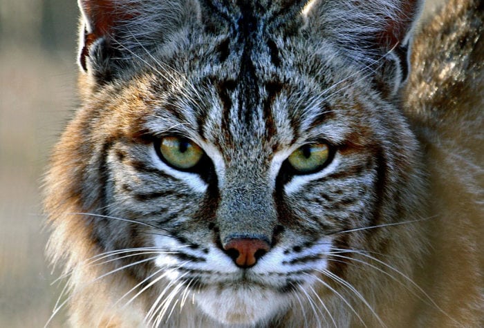
Bobcat
Found only in North America, where it is the most common wildcat, the bobcat takes its common name from its stubby, or “bobbed,” tail. The cats range in length from two to four feet and weigh 14 to 29 pounds. Bobcats mainly hunt rabbits and hares, but they will also eat rodents, birds, bats, and even adult deer.
Latin name: Lynx rufus fasciatus
watch
The Last Darkness
The Last Darkness
voices
Ursula K. Le Guin on ONDA

Ursula K. Le Guin on ONDA
“Nothing in conservation work is ever uncomplicated! But I’m proud of ONDA for working on that conversation, being neighborly, trying to include the human landscape in the natural one as truly part of what is to be honored, protected, and saved.”
Ursula K. Le Guin, from the short essay Concerning a Wilderness
Organizer: Stewardship Team
Project Timeline: 5/01/2024 through 10/31/2024
Region: Malheur National Forest
Difficulty Rating: Level 4: Strenuous
Volunteers Needed: No limit
About the place
ONDA’s conservation work takes place on the traditional lands of the Northern Paiute, Wasco, Warm Springs, Bannock and Shoshone people, as well as ceded lands of the Confederated Tribes of the Umatilla Indian Reservation, and on lands currently managed by the Burns Paiute Tribe and the Confederated Tribes of Warm Springs. Many Indigenous peoples live in Oregon’s high desert region today, including members of the Burns Paiute Tribe, the Confederated Tribes of Warm Springs (Wasco, Warm Springs and Paiute), the Klamath Tribes (Klamath, Modoc and Yahooskin) and the Fort McDermitt Paiute and Shoshone Tribe.
The Malheur River and North Fork Malheur River are known for outstanding scenery, geology, wildlife habitat and history. The river corridors are generally characterized by rugged and steep canyons ranging from 300 to 1,000 feet deep. The canyon geology is evident in the various rock outcrops, talus slopes and cliffs, contributing to the scenic diversity of the landscape. Scenic vistas from the canyon rims and views up and down canyon from the river are spectacular.
About the project
After two decades of legal pressure, the Forest Service is no longer authorizing livestock grazing along more than 64 miles of bull trout streams, covering more than 36,000 acres of national forest land in these two watersheds. Presumably in response to nascent habitat recovery, local bull trout populations also appear to be recovering. A number of allotment units along both rivers are permanently or temporarily closed to grazing.
This is a photo monitoring project
This project will involve taking new photos and visiting previous photo point locations to take current photos of the riparian conditions along identified stretches of the Malheur and North Fork Malheur Rivers and tributaries.
Timing
This project has about a five-month window (approximately May- October), and during this time you will be asked to find a day (or days…) to conduct the work….it’s all up to you!
Difficulty
This trip will require hiking, both on trail and off. Depending on the section of river you choose, your hike could be almost 10 miles, although many sections are shorter and more accessible. Some hiking will involve walking along brushy and thickly vegetated riparian corridors.
Registration
An ONDA registration application and medical form are required for this project. You will also have the option to volunteer for other projects that become available throughout the year.
Project Details
All the information you will need to know about this independent project will be emailed to you after your registration is complete. Each project page has extensive information about access, technology, tools, maps and more. Please be prepared to spend 1-2 hours reviewing this information prior to heading out on your project, the good news is that time spent reviewing and preparing for your trip all counts towards your volunteer hours.