South Fork Fence Build
Aaron Tani
success
Central Oregon’s “Backyard Wilderness”
Central Oregon’s “Backyard Wilderness”
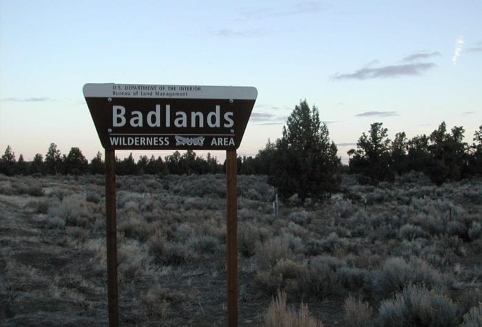
Our quest to protect the Oregon Badlands
Located just 15 miles east of Bend, Oregon Badlands is a 30,000-acre wilderness area filled with fascinating lava flows and ancient juniper trees Arriving in the Badlands, so named for its rugged and harsh terrain, can feel like stepping
Read Morevoices
Sarah Graham, Sage Sustainers Member
Sarah Graham, Sage Sustainers Member
“I contribute to ONDA monthly because it adds up to a larger annual gift than what I’d be able to comfortably afford if I were to do a simple one-time donation annually. I’m able to give more to ONDA this way and have greater impact which is important to me, and my dog Polly.”
voices
Cregg Large, member since 2009
Cregg Large, member since 2009
“I came to Oregon 12 years ago from Texas. Texas, for all its size, has very little public land. Coming to Oregon has made me realize the special gift we as Americans have in our public lands. Volunteering with an organization like ONDA is my way of reciprocating for this gift. Through restoration efforts, I feel we are helping leave a better place than we found it. Through advocating for protection for public lands, we safeguard migration routes for animals and keep the land where it belongs: with the public.”
Organizer: Jefferson Jacobs
Dates: May 18- May 21, 2023
Region: Central Oregon
Difficulty Rating: Level 5: Extreme
Maximum Group Size: 16 participants
About the place
This project takes place on the traditional lands of the Northern Paiute, Wasco and Warm Springs people. Many Indigenous peoples live in Oregon’s high desert region today, including members of the Burns Paiute Tribe, the Confederated Tribes of Warm Springs (Wasco, Warm Springs and Paiute), the Klamath Tribes (Klamath, Modoc and Yahooskin) and the Fort McDermitt Paiute and Shoshone Tribe.
The South Fork of the Crooked River has its source just to the south of the South Fork Crooked River Wilderness Study Area (WSA). After the river carves its way north through the canyon in the WSA it passes through a patchwork of BLM lands and private ranches before reaching the mainstem of the Crooked River. Historically the South Fork was home to anadromous fish such as salmon and steelhead, and has been the site of successful redband trout reintroduction efforts in recent years. However, due to the eradication of beaver, riparian habitat loss from overgrazing, and irrigation withdrawals dewatering the creek, the river’s water temperatures have risen and habitat quality has plummeted. This trip will take place on an 80-acre inholding within the South Fork Wilderness Study Area owned by the Oregon Desert Land Trust. This inholding encompasses both banks of nearly three quarters of a mile of river.
About the stewardship work
This trip contributes to a multi-year effort to improve the habitat not only on the property involved but throughout the entire South Fork drainage.
Participants will backpack 3.5 miles up the river, where they will establish a camp for the duration of the trip. The main objective of this trip is to complete a multi-year process of constructing 1.6 miles of extremely rugged barbed wire fence around the inholding. This fence will exclude cattle, but not wildlife from the inholding, and will therefore set the stage for passive recovery of habitat, as well as allowing for restoration plantings to occur in the coming years. Most of the work will focus on completing the construction of gates and river crossings.
We will teach you everything you need to know about how to build barbed wire fence.
View photos from last years trip.
Trip timeline
- Thursday, May 18, 3 p.m.: Meet at the Jake Place property on the South Fork of the Crooked River. Prompt arrival will be critical to allow the group to begin hiking up the canyon together to establish camp.
- Friday-Saturday, May 19-20, 8 a.m. to 4 p.m.: Full days of work building fence away from camp.
- Sunday May 21, 8 a.m.: After breakfast we can pack up camp and hike back to the vehicles together.
Camp
The campsite is on a broad juniper and sage-brush bench along the river in the center of the inholding. There is plenty of room to spread out, and there are trees for shade. The site is remote, undeveloped and without amenities (other than being next to the river), and it is lovely. The access road to the trailhead is an unmaintained dirt road, but it is not too much for a Subaru, or even a regular, adventurous sedan driven carefully (in good weather). You will be able to park your vehicle in a secure location behind a locked gate on private land.
Difficulty
This trip will be physically demanding. While all the materials will have been flown out to the worksite and cached along the proposed fence route, participants will need to be able to backpack to the campsite, help carry in a few small hand-tools, and navigate steep hills along the fence route during the work itself. That being said, there will be many opportunities for taking breaks and switching up jobs which include clipping wire to posts, moving materials along the fence line and attaching stays.
Participant responsibilities
Participants are responsible for their own food and camping gear as well as transportation to and from the trip. Participants will need to be able to backpack their equipment 3.5 miles to the campsite. Sturdy off-trail ankle-high boots, long sleeves and eye protection (prescription eye glasses or sunglasses are suitable eye protection) are required for this trip. We recommend bringing your own work gloves to provide a comfortable fit, but it is not required.
Gear provided
ONDA will provide work gloves if you don’t have a pair, all the tools and materials required for the work, safety gear and excellent guidance in the field.
Registration
An ONDA registration application and medical form are required for this trip. Check the box next to each trip you would like to attend. You only need to fill this form out once per year.
Apply Now
You will receive a confirmation email within 2 weeks of submitting your form. The confirmation email will provide information regarding which trips you are on the “participant list” for, and which trips are full, and therefore you have been placed on the “wait list.”
Six weeks before the start of the trip, the trip leader will send out an RSVP to make sure everyone is still able to participate. Based on RSVPs, open spaces will be backfilled with people from the waitlist.
Three weeks before the trip start date, registered and confirmed participants will receive driving instructions, maps, and additional information in an email sent by the trip leader
If you have any questions in the meantime, please don’t hesitate to contact the trip leader.
Your Trip Leader
This trip will be led by Jefferson Jacobs. If you have questions, you can contact him at jjacobs@onda.org
Meet Jefferson