Appreciating Stormy Skies

Greg Burke

watch

Wildflower Poetry Reading

Wildflower Poetry Reading

listen

Greater Sage Grouse and Sparrows at Hart Mountain

Greater Sage Grouse and Sparrows at Hart Mountain

voices

Michelle Frisella, member since 2017

Michelle Frisella, member since 2017

So proud of ONDA and its members and volunteers. Such hard work gets done. To use an overused word, this is patriotism!

Cumulonimbus, stratocumulus

Bruce Couch

Location: Alvord desert | Photographer: Bruce Couch

Bright flashes of lightning illuminated distant cumulonimbus clouds and a shelf of stratocumulus clouds over the Alvord Desert. Lightning is the visible flow of negatively charged electrons from the base of the cloud toward the positively charged ground. Most lightning strikes occur within and between clouds, while only about 20 percent occur between the cloud and ground.  The dark streaks are rain, which may reach the ground or evaporate before reaching the ground.

Cumulonimbus is the “Tyrannosaurus Rex” of the ten main cloud types. It’s Latin name is derived from two words — cumulus meaning “heap” and nimbus meaning “rain.” Its base is low — typically below 6,500 feet above the ground — but its top can reach over 45,000 feet. The stratocumulus cloud is also a low cloud, but as its “strato” name implies, is a layered cloud and does not have the depth or produce the lightning for which cumulonimbus are famous.

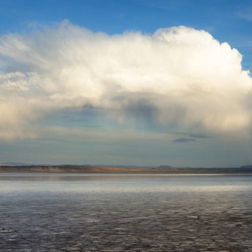
Cumulonimbus, nimbostratus

Greg Burke

Location: Hart Mountain, looking northeast | Photographer: Greg Burke

While most of our cloud types are capable of precipitating, cumulonimbus and nimbostratus bring us most of our rainfall. The Latin word nimbus means “rain.” Cumulonimbus are heaped clouds and tend to form, storm, and dissipate quickly; nimbostratus are layered clouds that move in more slowly, rain steadily, and often overstay their welcome. The clouds in this photo (to the northeast) appear to be cumulonimbus, both actively raining in the distance and perhaps older “rained out” ones in the foreground.

Interestingly, what these clouds are producing — rain — is actually snow melting on its way down from the inside of this deep cloud. The bright sunlight in the foreground and on this tee-pee suggest the sky is clear to the southwest. Knowing which way the storm is moving will help you decide whether to seek shelter or look forward to clearing skies.

Virga

Jim Davis

Location: West Little Owyhee | Photographer: Jim Davis

Falling streaks of snow obscure the clouds that produced this virga — precipitation that evaporates before it reaches the ground. This dramatic photo shows a mix of snow virga and, where it is smoothed out, rain virga (snow that has melted into rain).

Are virgae clouds? Not exactly. Virgae fall from the base of clouds—though the distinguishing between the base of the cloud and what is falling out of it can flummox even the most experienced meteorologists. The World Meteorological Organization, which is responsible for classifying and naming clouds, refers to virga as “supplementary features” of a cloud.

Cumulonimbus capillatus

Greg Burke

Location: Shirk Ranch, Guano Valley | Photographer: Greg Burke

Weathering more than a century of storms, the historic Shirk Ranch bunkhouse stands witness to perpetually dynamic skies of the Oregon high desert. Here, the mighty cumulonimbus cloud unleashes a curtain of rain from its base and an outburst of ice from its top. The quality of this cloud top — described as wispy or fibrous — makes this particular cloud a cumulonimbus capillatus, “capillatus” being the Latin word for “hair.”

Distinguish this from the tight, cauliflower-like top of the cumulus congestus cloud (on the horizon in the far right in the photo). This younger cloud may morph into a full-blown cumulonimbus before the sun sets. Both clouds are reflecting the “red” wavelengths present in sunlight. These long red wavelengths can penetrate the thicker portion of the atmosphere when the sun angle is low. The shorter blue wavelengths get scattered higher in the atmosphere to create our blue skies.


Catch High Desert Speaker Series

Join author Maria Mudd Ruth as she takes you on a tour of clouds in Oregon’s high desert and the wide-open, wild landscapes that make for spectacular cloud viewing. Learn what makes the clouds so dynamic, so varied, and so universally appealing. What are clouds made of? Is there an easy way to learn their confusing Latin names? How can you enjoy the clouds in a new light on your next high desert adventure?

Get Tickets

About the author

Maria Mudd Ruth is the author of more than a dozen natural history books for the young readers, general audiences and "accidental" naturalists, including "Rare Bird: Pursuing the Mystery of the Marbled Murrelet." Her latest book, "A Sideways Look at Clouds" (Mountaineers Books, September 2017) is a work of narrative nonfiction that blends science, wonder and humor to take lay readers on the scenic route through the clouds.

Watch More Clouds

Appreciating Stormy Skies

Maria Mudd Ruth, author of “A Sideways Look at Clouds,” is fascinated by clouds. In this post, she identifies the clouds seen in the stormy skies over Oregon’s high desert. […]

Read More

Appreciating Clouds

If you’ve ever looked out over the desert and wondered what type of clouds were filling the sky, you’ll love this post. We invited Maria Mudd Ruth, author of “A […]

Read More